This is the Nemo's Island
prototype. It shows the relationship of all the different areas and the
relationship of the different environments.
The island may change shape with input from the public and once the original design
document is fulfilled it could of course grow in size by just adding more real estate to
the shore areas - but most likely the island will be big enough that evolving ideas can
just be modified within the existing terrain.
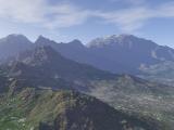
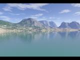
The map was made using Terragen!! - it is a true artist tool by the
fact it is powerful and flexible enough that it was used here for
a different purpose than it was really designed for. The landscape
pictures below are examples of its use - we will use it for our
sky-boxes. This program may seem special purpose but I am still
learning more about it - so like I have found - it is powerful - and has
just gone shareware - I did the map in version 6 - version 7 is out now!
Note: the maps in the 3 Level Plan are not good examples of
Terragen's beauty. They are taken from a vantage too far up and
not anti-aliased.
Click here to go get Terragen at their official site.
Click here for a website that has monthly
contests with Terragen users.
These 2 pictures produced by other users of Terragen
 Go
To Map |